Nepal and China Discussed Glacier Risks Before the Catastrophe
Three months before a devastating torrent of water, mud and rock swept through a Himalayan valley along the Nepal-China border, officials and experts from both countries met in Kathmandu to discuss the growing risks posed by floods, glaciers and extreme weather.
The meeting, held on May 27, brought together around 10 Nepali officials and roughly a dozen Chinese representatives, including officials from Tibet, according to an agenda prepared by the Nepali side and reviewed by Reuters.
The discussions focused on strengthening cooperation in monitoring and responding to floods, weather events and glacier-related hazards.
Officials discussed measures including glacial-lake inventories, hazard mapping and joint disaster-risk reduction.
However, Nepali officials later said that the country had not received as much information as it wanted regarding glacier movements, water levels and other hazards in the region.
The revelations have renewed attention on the importance of cross-border data sharing in the Himalayan region, where a disaster originating in a remote mountain area can rapidly affect communities many kilometres downstream.
Nepal Wanted Advance Information on Glacier Movements
Nepali officials said they had specifically sought information that could help authorities identify dangerous changes in glaciers before they developed into major disasters.
Sauhardra Joshi, a hydrologist with Nepal's Flood Forecasting Division who participated in the May meeting, said Nepal wanted advance information on early movements of glaciers and changes occurring around vulnerable areas.
Such information can be crucial because glacier collapses, landslides and sudden releases from glacial lakes can develop rapidly.
Unlike conventional river flooding, these events can combine huge quantities of water, ice, rocks and sediment, creating extremely destructive flows that may reach downstream settlements within a short period.
Data Sharing Did Not Meet Nepal's Expectations
Nepali officials said that discussions with Chinese representatives did not immediately result in the comprehensive data-sharing arrangement they were seeking.
Binod Parajuli, another Nepal government hydrologist, said Chinese representatives at the May meeting indicated that they did not have the mandate to sign an agreement covering Nepal's requests and called for further discussions.
Nepal was seeking information covering several categories of hazards, including:
-
Glacier movements
-
River and water levels
-
Avalanches
-
Landslides
-
Glacial lakes
-
Extreme weather events
-
Heavy precipitation
The lack of a comprehensive, real-time mechanism has become a significant point of discussion following the latest disaster.
China Says It Shared Information in a Timely Manner
China has rejected criticism that it failed to provide adequate information.
The Chinese embassy in Nepal said Beijing and Kathmandu had maintained close communication on disaster-related issues and had made substantial progress towards improving cross-border disaster information sharing during the May meeting.
The embassy also said Chinese and international experts faced considerable challenges monitoring hazards in the remote Himalayan region.
According to the embassy, Chinese teams had shared important information with Nepal in a timely manner.
China's Foreign Ministry did not respond to Reuters' request for comment specifically regarding the May meeting or Nepal's request for expanded information sharing.
Weather Forecasts Were Shared, but Hazard Monitoring Was Different
Nepali officials acknowledged that China had been providing information about heavy rainfall expected in Tibet.
Parajuli said Chinese authorities shared forecasts and observations when significant precipitation was expected, but that information related to avalanches, water levels, landslides and extreme events was not available to the same extent.
China had also begun sharing forecasts of heavy rain in Tibet with Nepal through WeChat and email approximately one month before the latest disaster, according to Parajuli.
The distinction is important because rainfall forecasts can indicate an increased possibility of flooding, while glacier and landslide monitoring requires a different set of tools and much more frequent observations.
China Issued a Warning Before the Disaster
Twelve days before the catastrophe, China's World Meteorological Centre sent an email to Nepali officials warning about an approaching monsoon depression.
The forecast indicated that rainfall was likely to increase across much of Nepal and warned of the potential for secondary and cascading hazards, including landslides and flash floods.
The warning demonstrated that meteorological information was being exchanged between the two countries.
However, the subsequent disaster showed the difficulty of predicting the precise location and timing of a glacier collapse, particularly in a remote and poorly monitored area.
Glacier Collapse Triggered a Catastrophic Flood
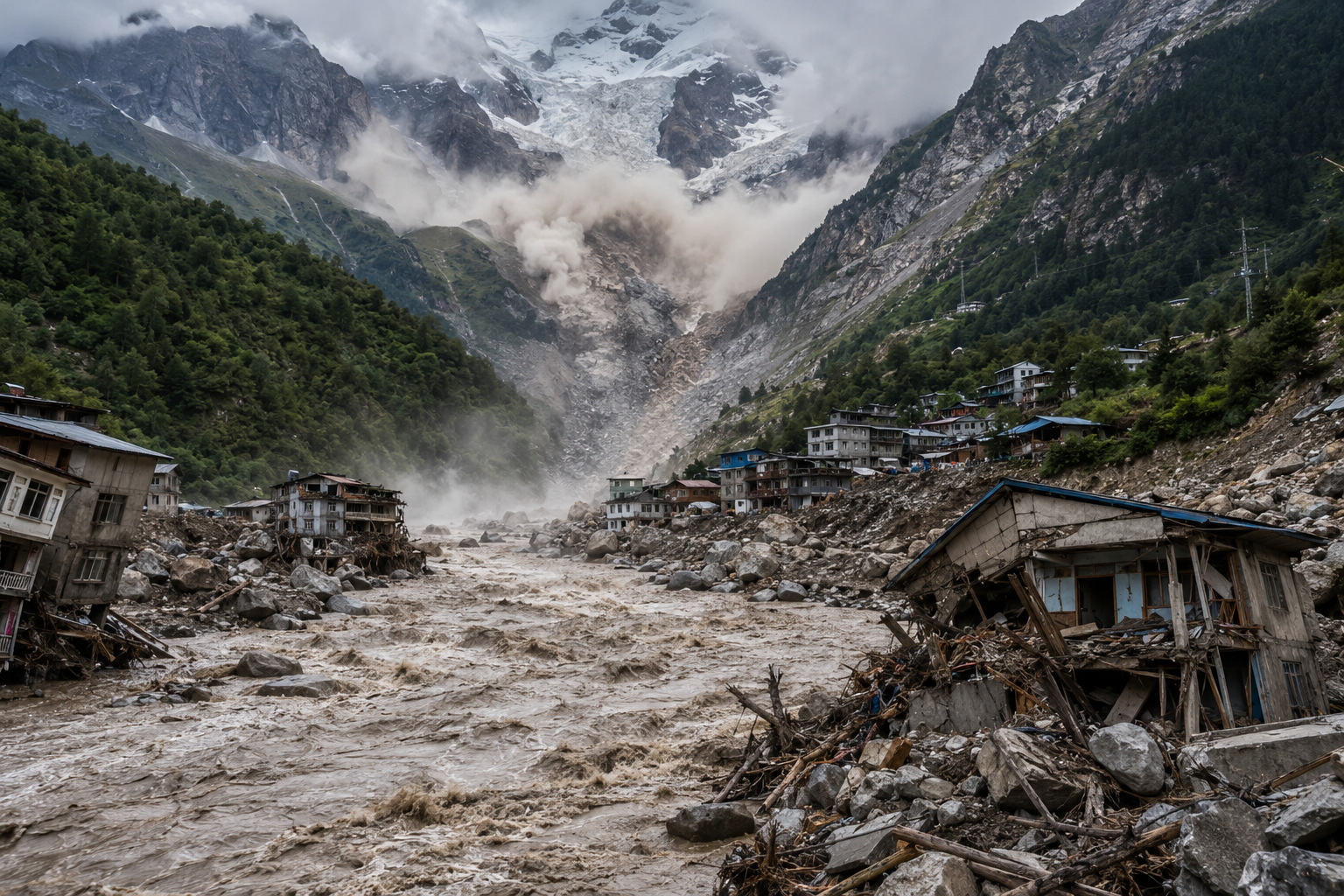
The disaster was triggered by the collapse of a glacier in a remote Himalayan area.
A large quantity of ice and rock crashed into the valley below, generating a high-speed flow of water, mud and debris.
The torrent then travelled approximately 168 kilometres downstream from the Nepal-China border, causing widespread destruction.
The disaster resulted in hundreds of deaths, while thousands of people were reported missing according to the latest figures cited in the report.
The scale of the event has highlighted the vulnerability of communities and infrastructure located downstream of unstable Himalayan terrain.
Critical Early-Warning Window Was Extremely Short
The sequence of events demonstrates the importance of real-time monitoring.
According to Parajuli, the flood struck a border crossing in Tibet at approximately 8:32 a.m. Nepal time on Wednesday.
Around 26 minutes later, he received a call from Nepal's National Disaster Risk Reduction and Management Authority reporting flooding on the Trishuli River.
Nepal's monitoring team then found that a border monitoring station had stopped transmitting data.
Officials attempted to contact downstream monitoring stations but found that data was also unavailable.
The team suspected that several monitoring devices had been washed away by the rapidly advancing flood.
After confirming the flooding with local authorities, Nepal issued a public alert to mobile-phone users at approximately 9:13 a.m.
The incident demonstrates how even a short delay in receiving upstream information can become critical when floodwaters are moving rapidly through mountainous terrain.
Monitoring Infrastructure Was Destroyed by the Flood
The disaster also damaged the very infrastructure designed to provide early warnings.
At least four monitoring stations were destroyed by the flood.
A Nepali government assessment estimated that the torrent carried approximately 57.4 million cubic metres of water, equivalent to around 2 billion cubic feet.
The volume was estimated to be more than half again as large as normal flow.
The destruction of monitoring stations highlights an important challenge for disaster-management authorities: early-warning infrastructure must be strategically positioned and sufficiently resilient to continue functioning during extreme events.
Bridges, Roads and Power Infrastructure Damaged
The flood caused widespread damage to critical infrastructure.
According to information cited by the Stimson Center, the flood damaged 19 bridges and approximately 40 kilometres of highway.
It also disrupted Nepal's electricity infrastructure and knocked out more than 10% of the country's power-generation capacity.
Such damage can have economic consequences long after floodwaters recede.
Destroyed bridges can isolate communities, damaged roads can disrupt trade and supply chains, while disruption to hydropower generation can affect electricity availability and industrial activity.
Residents Described a Massive Flow of Mud and Rock
People living downstream experienced the disaster as a sudden and extremely powerful surge rather than a conventional river flood.
Keshav Prasad Baral of Tupche village, located around 25 kilometres downstream from the border, described a huge flow of mud moving towards the settlement.
The combination of water, mud and large rocks increased the destructive force of the event.
Buildings, bridges and other infrastructure were swept away or damaged as the torrent moved through the valley.
Such events can provide little time for residents to evacuate unless upstream monitoring systems detect the hazard almost immediately.
Hindu Kush Himalayas Face Increasing Climate Risks
The disaster has also renewed concerns about climate-related risks across the Hindu Kush Himalayas.
The region contains one of the world's largest concentrations of ice outside the polar regions.
More than 63,700 glaciers cover approximately 56,000 square kilometres, according to information cited in the report.
These glaciers feed river systems that provide water to hundreds of millions of people across South and Central Asia.
Changes in temperature, snowfall and precipitation patterns are increasingly affecting the stability of these mountain environments.
Climate Change Could Increase Flood and Landslide Risks
Research cited in the report indicates that glacier melt is accelerating as snow cover declines and snowfall becomes more irregular.
These changes can increase the risk of several interconnected hazards.
As glaciers retreat, water can accumulate in glacial lakes. Unstable slopes can also become vulnerable to landslides and rockfalls.
Heavy rainfall can then trigger additional flooding or slope failures.
The combination of these hazards means that disaster-management systems cannot focus exclusively on rainfall or river levels. They increasingly need to monitor the entire mountain environment.
Several Major Rivers Begin in Tibet
The cross-border nature of the risk makes cooperation between Nepal and China particularly important.
Several major river systems flowing through Nepal originate in Tibet before moving through mountainous regions of Nepal.
These rivers pass through areas vulnerable to landslides, earthquakes, flash floods and other natural hazards.
An event in a remote upstream region can therefore have consequences for communities far downstream.
Real-time information sharing could give authorities additional time to issue evacuation warnings and move people away from vulnerable river corridors.
Himalayan Geography Makes Monitoring Difficult
Monitoring the Himalayan environment is technically challenging.
Many potentially dangerous glaciers, valleys and lakes are located in remote terrain that is difficult to access.
Harsh weather conditions, high altitude and limited telecommunications infrastructure can make the installation and maintenance of monitoring equipment difficult.
Satellite technology can provide broader coverage, but ground-based sensors are also important for measuring river levels and detecting rapid changes.
Building a reliable early-warning network therefore requires investment in multiple technologies rather than dependence on a single information source.
China Has Greater Monitoring Capacity
Environmental anthropologist Austin Lord, a senior fellow at the Washington-based Stimson Center, said Chinese scientists generally have greater resources and monitoring capacity than their counterparts on the Nepal side.
However, he also cautioned against treating the latest disaster as simply a consequence of inadequate bilateral cooperation.
According to the assessment cited in the report, the disaster originated in a relatively unmonitored area, and the limited level of cooperation was not considered a significant factor in Nepal's immediate response.
Nevertheless, the absence of a fully developed cross-border monitoring system remains a structural weakness.
Nepal Previously Raised Similar Concerns
The latest discussions were not the first time Nepal had raised concerns regarding glacier-related hazards with China.
Nepali officials said similar concerns were raised during a meeting last year.
That discussion followed a flood in the same broader region caused by the sudden release of water from a glacial lake in Tibet.
That earlier incident killed at least nine people in Nepal and left more than a dozen people missing.
The recurrence of such events has increased pressure for stronger cooperation on monitoring and early warnings.
Nepal Wants a Formal Data-Sharing Agreement
Following the latest disaster, Nepal plans to pursue a more formal arrangement with China.
Parajuli said Nepal's authorities would seek an agreement covering more frequent information on precipitation and river levels, similar to an existing arrangement between Nepal and India.
The proposed framework would provide information at intervals of around 10 minutes.
For rapidly developing flood events, such frequent data could potentially provide authorities with valuable additional time to issue warnings.
Nepal's objective is to ensure that information collected in upstream areas can be transmitted quickly to communities downstream.
Real-Time Data Could Improve Evacuation Planning
A more frequent information-sharing system could improve several aspects of disaster response.
Authorities could potentially:
-
Detect rapid changes in river levels
-
Identify abnormal water flows
-
Track rainfall intensity
-
Monitor glacial lakes
-
Assess potential downstream impacts
-
Trigger mobile-phone alerts
-
Coordinate evacuation efforts
-
Position emergency-response teams in advance
The effectiveness of such a system, however, would depend on the reliability of monitoring equipment, communications networks and emergency-response infrastructure.
Early Warning Must Be Combined With Local Preparedness
Technology alone cannot eliminate disaster risk.
Even if authorities receive information within minutes, communities need clear evacuation routes, warning systems and emergency shelters.
Local governments also need trained personnel who can interpret data quickly and make decisions under pressure.
Regular drills and public awareness campaigns could help communities respond more effectively when warnings are issued.
The latest disaster has therefore highlighted the need for an integrated approach combining data, technology, infrastructure and community preparedness.
Economic Cost Could Extend Beyond Immediate Damage
The consequences of the disaster are expected to extend beyond the immediate loss of lives and physical destruction.
Road and bridge damage can disrupt transportation and trade.
Damage to hydropower infrastructure can affect electricity generation.
Businesses operating in affected areas may face prolonged interruptions, while reconstruction could require substantial government expenditure.
The economic burden is particularly significant for Nepal, where mountainous infrastructure can be expensive to build and difficult to repair.
Disaster Risk Could Influence Infrastructure Planning
The latest event could also influence how future infrastructure projects are planned in the Himalayan region.
Roads, bridges, hydropower projects and settlements may need to account more carefully for changing patterns of glacier melt, rainfall and landslide activity.
Greater use of hazard mapping and climate-risk assessments could help governments identify areas where infrastructure faces elevated exposure.
Investments in resilient construction and redundant communication networks could also reduce the impact of future disasters.
Cross-Border Cooperation Becomes More Important
The latest tragedy has demonstrated that natural hazards can cross national boundaries even when political boundaries remain fixed.
A glacier collapse or landslide originating in one country can rapidly affect communities in another.
For this reason, disaster-risk management in the Himalayan region increasingly requires cooperation between neighbouring countries.
Regular exchange of data, joint research, shared monitoring systems and coordinated emergency protocols could improve regional preparedness.
Focus Shifts From Blame to Future Preparedness
Neither Nepali nor Chinese officials have formally blamed the other side for the disaster.
Experts have stressed that forecasting glacier collapses in remote Himalayan terrain remains extremely difficult.
The more immediate issue is how to improve the systems available before the next disaster occurs.
Nepal's push for more frequent data from China reflects a broader effort to reduce the information gap between upstream hazard zones and downstream communities.
A Broader Warning for South Asia
The implications of the disaster extend beyond Nepal and China.
The Hindu Kush Himalayas are closely connected to the water security, agriculture, energy production and economies of a large part of Asia.
Changes in glaciers and snow patterns can affect river flows over both the short and long term.
At the same time, sudden glacier-related disasters can threaten settlements and infrastructure located along mountain rivers.
The need for investment in climate adaptation, disaster monitoring and resilient infrastructure is therefore becoming increasingly urgent across the region.
Market Outlook
The latest Himalayan disaster is likely to increase the focus on climate-resilient infrastructure, satellite-based monitoring, early-warning systems, hydropower safety, disaster-management technology and cross-border environmental data networks. Nepal's proposed system for receiving information at roughly 10-minute intervals could become an important step towards improving preparedness if implemented with reliable infrastructure and effective communication protocols. Over the longer term, increasing climate risks could drive greater investment in glacier monitoring, river-gauge networks, resilient roads and bridges, hydropower protection, emergency communications and community-level disaster preparedness across the Himalayan region.